
Distance

Time

Ascent

Highest point

Difficulty

Paved
Last updated Oct 26, 2018
Need to know details
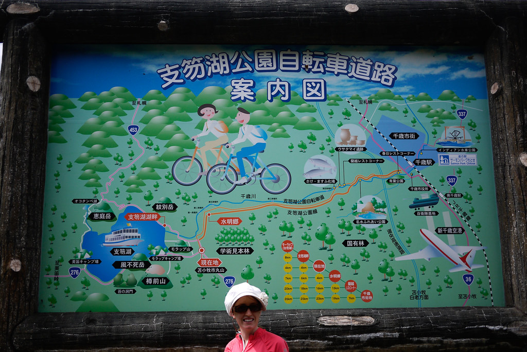
This cycleway links Chitose City and Lake Shikotsu, about 50km south of Sapporo City.
Most cyclists will probably start from the Chitose end, but it is possible to link this cycle road up with the Sapporo-Shikotsu-ko ‘cycle road’ (which is actually just a sidewalk next to the main road) to create a nice long day trip. An equally appealing option might be to make it a day trip from Chitose to the lake and back again, with a nice swim in the middle; Lake Shikotsu is undoubtedly one of the cleanest lakes in Japan. What you see floating on the surface of the lake is natural pumice; Lake Shikotsu is a volcanic lake. Below are some other Hokkaido Wilds route guides that utilize this cycleway.
Route markers
The cycleway is well-marked.
The route is all uphill on the way from Chitose to the Lake, so bank on between 2-3 hours to the lake, and about 2 hours on the way back to Chitose.
Explore the official Japan topomaps online for the area around Chitose-Shikotsu Cycleway here. Follow these instructions to print out the area you would like as a hardcopy.
Weather forecast
Shikotsu Village is home to a number of excellent onsen. Lake Shikotsu Kyuka-no-Mura (支笏湖休暇の村, here) is the cheapest, but we recommend the very up-market Mizu-no-Uta onsen (水の歌, here). An onsen on its own here is about 1,000yen, so their 2,000yen buffet lunch and onsen set is a pretty good deal. So consider booking ahead and treating yourself (NOTE: The price indicated on the Japanese page is 2,000yen, on the English page it says 3,240yen…we’ve only ever paid 2,000yen).
Support us
Like this content? Buy the HokkaidoWilds.org team a coffee. 50% of tips go to the Hokkaido Wilds Foundation.
As with each ski touring, cycle touring, and hiking route guide published on hokkaidowilds.org, should you choose to follow the information on this page, do so at your own risk. Prior to setting out check current local weather, conditions, and land/road/track closures. While traveling, obey all public and private land use restrictions and rules, carry proper safety and navigational equipment, and of course, follow leave-no-trace procedures. The information found herein is simply a planning resource to be used as a point of inspiration in conjunction with your own due-diligence. In spite of the fact that this information, associated GPS track (GPX, KML and maps), and all information was prepared under diligent research by the specified contributor and/or contributors, the accuracy of such and judgement of the author is not guaranteed. hokkaidowilds.org, its partners, associates, and contributors are in no way liable for personal injury, damage to personal property, or any other such situation that might happen to individuals following the information contained in this post.
hokkaidowilds.orgに掲載されるすべてのスキールート、自転車ツーリングルート、ハイキングルートと同様に、本ページに掲載される情報を利用し行動する場合、必ず自己責任で利用することを条件とします。出発する前に現地の天候や状況、通行止め情報などを確認しましょう。行動中は、公有地/私有地に関係なく必ず現地の利用条件を守るようにし、適切な安全装置や、コンパスや地図などのナビゲーション道具を身に着けてください。いうまでもありませんが、自然に与える人間の影響を少なくし、ゴミの持ち帰りをはじめ環境を傷をつけない(Leave No Trace)ようなアウトドア行動にしましょう。本サイトに掲載される情報はあくまで計画を立てるための一つの情報源に過ぎなく、行為者の先んじて払ってしかるべき正当な注意義務及び努力と合わせて利用することを条件とします。本ページのGPSトラック(GPXとKMLと地図)を含む情報は提供者のできる限り正確な調べにより提供しているものの、その情報の正確性や、提供者の行動判断は、hokkaidowilds.orgは一切の責任を負いかねなく保証できません。また、本ページに掲載される情報を利用することによるいかなる怪我、器物損壊等、その他事件 ・事故等においてhokkaidowilds.orgや本サイトの関係者は一切の責任を負いかねます。
Comments | Queries | Reports
Done this route up to Chitose-Shikotsu Cycleway? Thinking of doing it? Please post any feedback or queries here. Thanks!



1 thought on “Chitose-Shikotsu Cycleway”
Hey I've never been to Hokaido. Wow. I never thought it was so beautiful there.