Distance sailed today:113 NM
Total distance sailed: 2386 NM
Midnight GPS position: N 19.40 W057.46
Wind: E Wind Force 2-4
Sea state: Slight
Generator hours: 7.3hr
When I awoke at midnight to begin my four hour graveyard watch, it was smooth sailing. I was taking over from Steve. “Very nice sailing so far, Rob. Thirteen to fifteen knots steady on our tail, barometer is steady, should be a nice watch for you,” he said as he wandered down to bed.
Fifteen minutes later, by 12:15am, the wind was getting up to 27 knots. By the end of my watch I had experienced wind speeds of 8 to 27 knots, wind shifts of up to 40 degrees either way, and some light rain. After I handed over to Ellie for her watch at 4am, the weather settled down and she had a nice settled watch. I guess it was just my lucky four hours.
At times like that, it’s Skipper Steve who has the toughest time. He’s the one ultimately responsible for the boat and crew, so naturally he has a vested interest to ensure that I am on top of things. This means that he was up for at least half of my watch, ensuring that the weather conditions were handled correctly. Which means that he got much less sleep that the rest of us.
As for the low pressure system that we have been watching today, the possible tropical cyclone has been made Tropical Storm number 8 according to today’s weather fax.
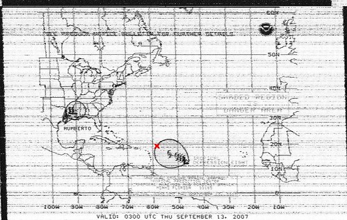
Our present position is marked as a big red ‘x’. You’ll notice that it is almost inside the big grey area that indicates a possible affected area by Tropical Storm 8. This weather map however is a 48 hour forecast. In 48 hours, we will be 300 miles west of our present position, therefore we should be able to keep just in front of the storm.
We still have about 400 miles to go until we get to our ultimate destination, which is Tortola, on the British Virgin Islands. However Steve has decided to keep well clear of the tropical storm, and we are now heading for St. Micheal Island, some 100 miles closer to us than the British Virgin Islands. It is the closest island to us of the Lesser Antillies. According to our calculations, we have just enough fuel left to motor all the way to St. Micheal island, so at least we do not have to rely on wind in order to escape the storm. We will motor all the way to St. Micheal island and refuel there before reasessing out options for getting the rest of the way to Tortola, keeping in mind the approaching storm.
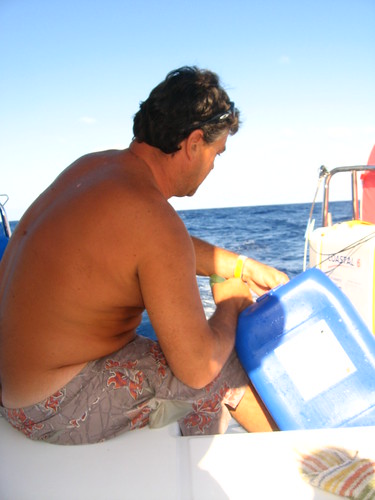
Steve refueling the boat using cans of diesel.